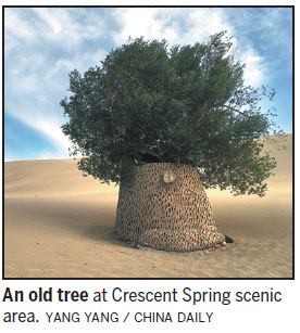
It was the longest day of the year, and the sun would finally disappear below the horizon only after 9:30 pm. As tour buses slowly rolled into the Crescent Spring scenic area in Dunhuang, Gansu province, excited passengers held their cameras and mobile phones aloft, eager to get shots, on both sides of the road, of the sand dunes at the foot of Singing Sands Mountain.
To eyes looking on from afar in fading light, these gigantic dunes could easily have been dinosaurs - albeit ones with silky smooth skin - resting quietly on their bellies and about to settle in for the night.
Although it was still hot out in the open, the sand dunes, stretching this way and that as far as the eye could see, seemed to work a cooling, soothing magic, particularly the nearer we got to the small lake in the crescent-shaped area that gives the place its name. It is a traveler's oasis where, at the end of a long journey, green plants can be seen once again.
|
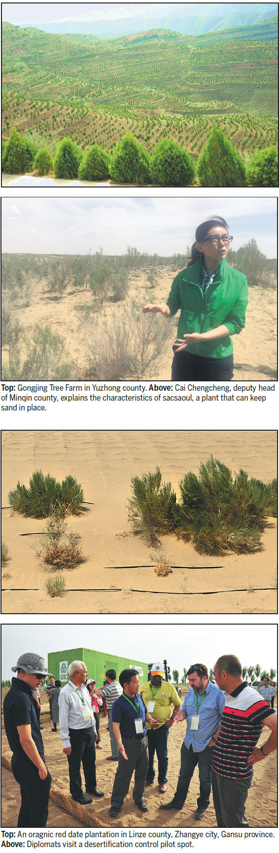
Caragana is planted on the loess plateau in Yuzhong county, Lanzhou, Gansu province to preserve rainwater and soil. Photos by Yang Yang / China Daily |
Shogo Masuda, an official with the Japanese embassy in Beijing and one of 15 diplomats in the delegation on the trip, which was aimed at showcasing the Chinese government's efforts to deploy all the forces of forestation to halt the march of the spreading desert, called me over, keen to show me something he had just discovered after digging a hole in the sand beside the lake.
"It gets moister the deeper you dig," he said.
It was true, and the sand felt cooler when my bare foot touched the bottom. I looked around and noticed that the south bank of the spring looked darker.
"The spring used to be much larger," I said, recalling what I had read earlier about how it has shrunk.
Dunhuang has average rainfall of less than 50 millimeters a year, but in that time about 60 times that amount evaporates. However, for thousands of years the natural wonder that is Crescent Spring has been happy to cock a snook at the aridity that surrounds it.
Fifty years ago, the spring, drawing water from below, was about 10 meters deep and covered about 15,000 square meters. However, since the 1970s, the water level has dropped by as much as 10 meters, in line with that of Dunhuang generally, meaning that the well has at times been virtually dry.
In 2004, locals mobilized to rescue the well by adding water to it. The water level is now stable after having risen from between 0.1 m and 0.5 m to about 0.7 m to 1 m in the past 13 years.
"However, it will be extremely hard to get it back to its original natural state," says Zhang Mingquan, a professor of environmental sciences at Lanzhou University.
Another threat to the spring is the surrounding sand. Without proper desertification control, the spring would probably be buried, says Qu Jianjun, researcher at the Cold and Arid Regions Environmental and Engineering Research Institute, part of the Chinese Academy of Sciences. The main measure is to fell tall poplar trees and demolish buildings to create a wind tunnel for northeasterly winds, he says.
Dunhuang was the last stop on a five-day journey that started in the provincial capital, Lanzhou, 1,100 kilometers to the southeast, where the achievements of the Three-North Forest Shelter Belt Development Program and the great combat against desertification in China for nearly 40 years are on display.
In November 1978, China started planning huge shelter belts in the country's north to mitigate drought, sandstorms and soil erosion. The program covers 42 percent of China's land area.
China is not alone in its fight. Worldwide, creeping deserts pose a threat, and according to the United Nations, 6.6 percent of the land on Earth is covered with deserts, and 34.6 percent is drylands. Worldwide, 2.1 billion people live in deserts and drylands, and 110 countries are facing the problem of land degrading.
Every year, 12 million hectares of land are lost.
In China, although the combat against desertification is helping gradually reduce the area covered by sand, there were still 2.6 million square kilometers of such land at the end of 2014, about 27 percent of the whole territory.
There also were 1.7 million sq km of sandified land, about 18 percent of the national territory, the State Forestry Administration says.
More than 43 percent of Gansu's surface area, 195,000 sq km, is desert, and more than 27 percent, 120,000 sq km, is sandified. This fragile environment greatly hobbles the province's economic growth.
Nevertheless, efforts to rein in desertification have borne fruit over the past eight years, with the province's desert land shrinking by 1,914 sq km and its sandified land by 742 sq km.
More than 1,000 companies engaged in this fight have been set up in the province over that time, and they are reckoned to have annual turnover of 15.3 billion yuan ($2.3 billion; 1.9 billion euros; £1.7 billion).
Of course, Crescent Spring is just one token of the battle against creeping deserts.
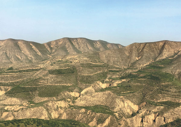
Starting from Lanzhou, the delegation traveled along the 1,000-km Hexi Corridor, the artery that connects China with the Tarim Basin and Central Asia and served as a conduit for Buddhism, trade and military ventures in ancient times. In the corridor, west of the Yellow River, four oases are strung along from east to west among deserts and semidesert: Wuwei, Zhangye, Jiuquan and Dunhuang.
The landscape on both sides of the highway between Qilian Mountain in the west and Heli Mountain in the east changes continuously from semidesert on which tough, short shrubs grow, then land with more shrubs and green land on which taller trees grow.
The change is particularly noticeable if you take the high-speed train that traverses the vast barren semidesert of Jiuquan, passes by Jiayuguan, where the western end of the Great Wall, built during the Ming Dynasty (1368-1644), is located, and takes you to Liuyuan South Station, northeast of Dunhuang.
In the 90-minute drive from the train station to downtown Dunhuang, it is easy to see the changes of landscape from semidesert, the wetter land where clusters of rose willow grow, and where trees and crops grow, and the green expanses on the outskirts of the city, where the kinds of landscape seen earlier are scarcely imaginable.
Heritage site
Mogao Caves, the UNESCO World Heritage site that is a 50-minute drive from Crescent Spring, is on the southeastern edge of the Kumtagh Desert, one of the largest deserts in China, and at the foot of Singing Sands Mountain. The weather is dry, and flying sand, carried along by fierce winds, is a frequent, if not constant, companion. In preserving the 1,600-year-old grottoes, dryness has been an ally, but the wind and sand damage the caves and murals. In the 1940s, the entrance of the caves was buried in sand.
At the entrance of cave No 17 of Mogao Caves, guides invite visitors to inspect the scars that sand has left on walls, sand that buried the entrance of the cave completely, too, before the Taoist priest Wang Yuanlu discovered thousands of rolls of Buddhist sutra in the cave in 1900.
"Carried along by the wind are minute sand particles invisible to the naked eye, and these things have sharp corners and edges that cut into the surface of murals, degrading the color," says Zhang Guobin of the Dunhuang Academy, who is in charge of sand control.
On the top of the Mogao Caves, wind blows mainly from three directions, northeast, northwest and, most frequently, south. These winds carry with them sand from Singing Sands Mountain and the nearby Gobi Desert.
After studying the wind conditions and the flow of the moving sand, researchers have taken steps to combat the erosion of wind and sand.
They have built A-shaped barriers so that the sand that northwesterly winds carry along is blown back by winds from the northeast. This reduces sand moved by northwesterly winds by 95 percent, and sand accumulated at night by 60 percent.
They have also created a man-made semidesert, pressing stones of certain sizes into the sand to prevent it from flying.
"Ten years ago, all this fine sand would blow in the wind," Zhang says. "Now, in creating this man-made semidesert, we have brought in pebbles from 15 kilometers away, and with the one-kilometer long plant barrier, moving sand won't accumulate here."
Checkbox barriers
In addition, woven straw or nylon nets have been buried in the sand to form checkbox barriers against the wind. Once sand is ensconced in these barriers, windbreaking seedlings such as Calligonum, caragana and sacsaoul, which are resistant to drought and cold, are planted in the center of the boxes.
In the past 10 years, Li Rui, 40, one of the four workers responsible for sand control with Dunhuang Academy, says he has seen more than 1.15 million square meters of checkbox barriers built.
He and others constantly monitor the top of the sand mountain, ensuring that the checkboxes and plants are doing their job. At the foot of these boxes and plants run black rubber pipes that transport water to the top of the sand mountain, dripping it into the sand to promote growth.
Sometimes the workers help research institutes with experiments such as building a wind tunnel to determine the ideal density of grit, and the size of its particles, that is spread on the surface of sand to stop it from blowing in the wind.
yangyangs@chinadaily.com.cn
(China Daily European Weekly 08/04/2017 page1)